Storm Ciarán to Unleash Devastating Winds and Record-Breaking Waves in Western Europe
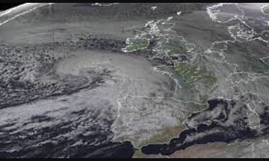
Western Europe braces for one of the strongest storms in decades as Storm Ciarán approaches, bringing heavy rain, fierce winds, and high waves. Residents advised to stay home and prepare for potential damage. Climate experts highlight the increasing severity of such events due to global warming.
France, England, and other countries in western Europe are preparing for what could be some of the strongest wind speeds seen in decades as Storm Ciarán approaches. The storm is expected to bring heavy rain and winds of up to 105 miles per hour to northwestern France, with waves reaching almost 33 feet high. In the UK, severe weather warnings have been issued for coastal areas, with winds expected to reach around 80 miles per hour.
Sidmouth got it quite bad. Sheeeet!!! #StormCiaran pic.twitter.com/b4mOVk1iVk
— 𝓙 (@rxlyjf) November 1, 2023
The Channel Islands and the east of England are likely to experience the worst of the storm, but much of the south and southeast will also be affected. Residents have been advised to stay home, close shutters, and prepare emergency kits. The storm is the result of a branch of the jet stream heading towards northern Europe, intensifying a low-pressure area and causing the storm. While there is uncertainty about the exact track of the storm, it has the potential to cause significant damage. Climate experts warn that extreme weather events like this are becoming more severe due to global warming, with increased rainfall and rising sea levels leading to more damaging storm surges.


